Saya de Malha bank, Mascarene Plateau
Location/ Description / Jurisdiction / Features of Potential Outstanding Universal Values / Threats / Management status / Geographic scale and site integrity/ Site type/ Other sites in the region / Key References
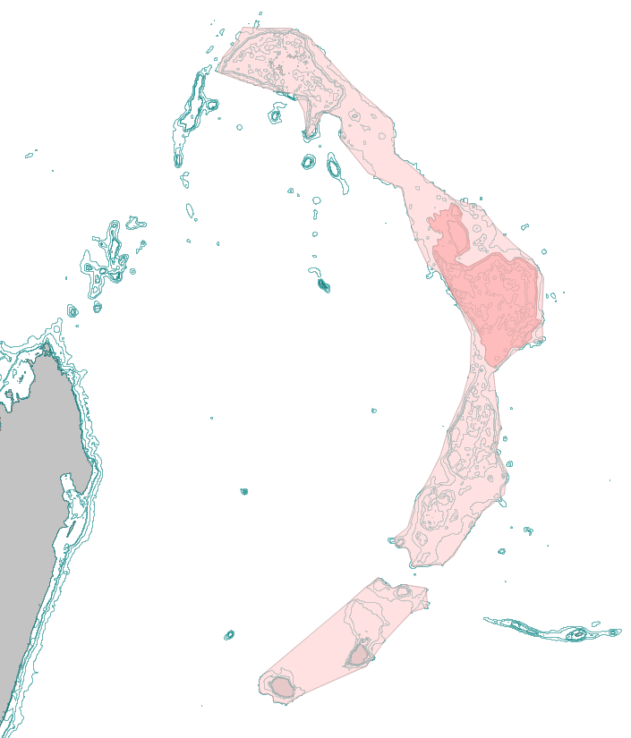
 The Mascarane Plateau, stretching from the N. Seychelles Bank in the north to St. Brandons Island in the south (with the isolated Mascarene Islands shown to the south). The S. de Malha bank is the eastern point of the arc, and the largest bank. The Mascarane Plateau, stretching from the N. Seychelles Bank in the north to St. Brandons Island in the south (with the isolated Mascarene Islands shown to the south). The S. de Malha bank is the eastern point of the arc, and the largest bank.
© David Obura
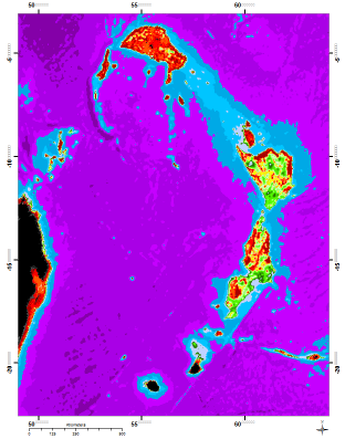
 The Mascarene plateau, colour-coded by depth: red and yellow show areas shallower than 125 m, green to 500 m, and blue to 4000 m. The Mascarene plateau, colour-coded by depth: red and yellow show areas shallower than 125 m, green to 500 m, and blue to 4000 m.
© etopo
|
Location - The Mascarene Plateau includes the products of the Mascarene-Reunion hotspot in the WIO, thus extends from the island of Reunion in the south to Saya de Malha in the north. Loosely, it can also be extended northwards to include the Ritchie Plateau and North Seychelles Banks, which are continental fragments left behind as Indian migrated northwards. The Saya de Malha bank, located between 8°30 - 12°S and 59°30 - 62.30°E, is the largest of the banks on the plateau, with an area of approximately 40,000 km².
Description - The basement rock of the bank was formed by the Mascarene-Reunion hotspot about 40-45 mya, as part of the island-arc series that started with the Deccan Traps in India (64-67 mya) is still active forming the island of Reunion (2 mya to present). The Cretaceous-Tertiary (K-T) extinction event associated with the superplume event that started activity of the Mascarene-Reunion hotspot drove approximately 30% of marine genera to extinction, along with the dinosaurs, opening evolutionary space and potentially a unique evolutionary history for marine species in the Western Indian Ocean.
The S. de Malha Bank is now capped by carbonate deposits due to sedimentation of carbonate-forming plankton along with shallow carbonate reef growth where possible. An oil drilling core taken at the northwest corner of the main bank found carbonate rock to a depth of over 2400 m, of which the top 1250 m were described as ‘reef carbonates’. The volcanic rock may have been exposed as a large island up to 300 km across its longest diameter, from the time of its formation and for several 10s of millions of years subsequently. A classic example of island subduction and sinking and coral reef and carbonate platform growth over time, as first theorized by Charles Darwin, the Saya de Malha bank is now a submerged carbonate plateau. The bank is described as being flat, but considerable depth variation occurs across its top, with the shallowest being a crest less then 75 m deep to the north and east, with patches west of this and at the northwest side, and depressions down to 300-400 m depth in the center of the bank. The entire bank is clearly differentiated at the 500 m contour from the deep ocean surrounding it. With no exposed island mass, the waters over the bank are a globally unique mid-ocean shallow sea.
The smaller northern bank, the Ritchie plateau, is separated from the main bank by a transform fault, and is part of the granitic continental rocks of the Seychelles bank and the ridge extending between them in a NW-SE direction. South of the Saya de Malha bank, the Nazareth and Cargados Carajos banks are of similar construction, but younger, and only St. Brandon’s island, at the southern end of the Cargados Carajos bank, has any aerially exposed landmass.
The Saya de Malha bank sits in the path of the South Equatorial Current (SEC), that dominates the oceanography of the WIO, and together with its sister plateau to the south, the younger Nazareth bank, concentrates flow of the SEC into a narrow passage between them at 12.5-13°S. The bank thus has a major influence on the oceanography of the WIO and regions to the west. Only a small proportion of the SEC passes north of the bank as a slow, broad current, and island wakes and eddies in the lee of the bank may result in higher oceanic productivity due to mixing and upwelling. The influence of these features on the connectivity of the marine fauna of the bank and plateau system, with other coralline islands in the Seychelles, and for the WIO in general, is presently unknown.
Current knowledge holds that the bank supports the largest contiguous seagrass beds in the world, with 80-90% of shallow surfaces being covered by seagrasses dominated almost exclusively by Thalassondendron ciliatum, from depths up to 30-40 m, with additional records of Halophila decipiens and Enhalus acoroides. Coral reefs appear limited to rocky patches and outcrops, and likely to the edges of the bank.
Enhanced oceanic productivity caused by interaction of the banks with the South Equatorial Current is likely important for ocean food webs, and as indicated by seabirds using the Seychelles Basin (shown for wedge-tailed shearwaters and white-tailed tropicbirds), and for the pygmy blue whale (Balaenoptera musculus brevicauda) as a feeding and breeding ground.
Jurisdiction - Historically considered to be beyond national jurisdiction, the Mascarene Plateau was the subject of a successful joint application by the governments of the Seychelles and Mauritius, under the United Nations Convention on the Law of the Sea (UNCLOS) Commission on the Limits of the Continental Shelf, to extend their Outer Continental Shelf. Hence, the seabed is jointly managed by Mauritius and the Seychelles, while the water column remains in the high seas. Approved in 2010, this gives the governments the opportunity to exploit the marine resources in an additional maritime zone of 396,000 km² on the Mascarene Plateau.
|
Features of Potential Outstanding Universal Values
Criterion viii - Geology and oceanography
The Mascarene Plateau presents a superlative example of hotspot/spreading ridge interactions and mid-ocean example of island subsidence and carbonate reef and bank formation.
The Saya de Malha Bank is the largest bank of its type in the Indian Ocean.
Ocean-platform interactions result in raised productivity on and downstream of the banks |
Criterion x - Habitats and conservation
The S. de Malha Bank supports the largest seagrass beds in the world, and it and the other banks form a large contiguous and unexploited shallow marine habitat that supports production in the surrounding ocean.
Breeding grounds for the pygmy blue whale Balaenoptera musculus brevicauda. |
Criterion ix - Ecology, species and evolution
The Mascarene Plateau is part of the earth and climate processes that played a role in the K-T extinction (superplume event) and cenozoic evolutionary mechanisms in the WIO. |
|
The Saya de Malha bank has been identified as globally important in two independent processes:
-
The technical process in support of the Convention on Biological Diversity used the bank as an illustration of a likely Ecologically or Biologically Significant Area (EBSA), satisfying four of the seven criteria: 1. Uniqueness or rarity; 2. Special importance for life history stages of species; 3. Importance for threatened, endangered or declining species and/or habitats; and 5. Biological productivity. A CBD Indian Ocean regional workshop to formally describe EBSAs will further this work in August 2012.
-
A separate analysis by WWF, as part of the Western Indian Ocean Marine Ecoregion (WIOMER) and ‘Réseau des Aires Marines Protégés’ project of the Indian Ocean Commission (RAMP-COI) scored Saya de Malha as high for the other 3 EBSA criteria: 4. Vulnerability, Fragility, Sensitivity, or Slow recovery; 6. Biological diversity; and 7. Naturalness; and has selected it as a priority seascape of global significance for its ecoregional conservation strategy.
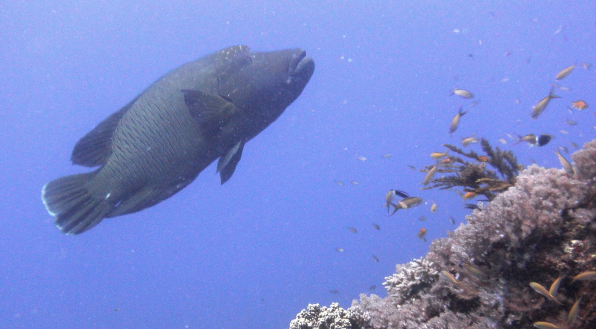
|  The remote banks may be among the last refuges for Napoleon wrasse (Cheilinus undulats). This species is highy vulnerable to fishing, and was listed as Engangered on the IUCN Red List, in 2010. The remote banks may be among the last refuges for Napoleon wrasse (Cheilinus undulats). This species is highy vulnerable to fishing, and was listed as Engangered on the IUCN Red List, in 2010.
© Melita Samoilys
 The Saya de Malha bank may host the largest seagrass
beds in the world, on its shallow east and northern rims. The Saya de Malha bank may host the largest seagrass
beds in the world, on its shallow east and northern rims.
© Cheryl-Samantha Owen/ www.samowenphotography.com
|
Threats - The remoteness of the bank has protected it from threats, much as it has prevented much research and data collection. Nevertheless, vessels from distant-water fishing nations (DWFN) operate in the Indian Ocean and and Mauritian vessels target the bank and adjacent ones. Prospecting for seabed metals and oil and gas mining have returned weak results, so the threat from them is currently considered low. Climate change is a significant threat for the carbonate-dominated food webs of the shallow banks.
Management status - Future management of the S. de Malha bank will depend on joint arrangements by the Seychelles and Mauritius, and national priorities such as in fisheries. Management, surveillance and enforcement of a distant marine zone with no emergent land to host a management base will be challenging, but increasingly possible with the advent of remote sensing surveillance technologies, and existing operationalization of them in, for example, fisheries management and vessel surveillance. National legislation to enable management of this type of distant marine site would be necessary. WWF is proposing for discussion with Mauritius and Seychelles to carry out a “feasibility study” to (i) analyse the existing international and regional conventions and conservation and management tools that provide guidance for appropriate legal regime, conservation and fisheries management measures and type of governance for the Saya de Malha Banks, and (ii) propose a statement of strategy and action plan for the short, medium and long-term.
Geographic scale and integrity issues - The S. de Malha bank is the largest single bank in the Indian Ocean, larger than the Great Chagos Bank. There is no human habitation on or near the bank as there is no emergent land. Thus the ecological integrity of the bank is very high, and a nomination that includes the whole bank will meet the highest level of integrity possible. Nomination of a portion of the bank would result in slightly lower integrity of the nomination site, but the lack of current threats, and successful management planning in the future, would ensure high enough integrity for sustainability of a site.
Site type - As presented here, the Saya de Malha bank could either be considered as a transboundary single site nomination, jointly by the governments of the Seychelles and Mauritius. Alternatively, if only part(s) of the bank is(are) selected, single-country nominations would be possible. With different geological origins, sites on the south bank and north/Ritchie bank could be selected. Further, the EEZ extension application by the Seychelles and Mauritius applies to the seabed, while the water column is an ABNJ, and in the High Seas.
Other sites in the region - The Mascarene Plateau is a unique geological feature globally.
Key References – Ardron et al. (2009); Brooke et al. (2010); Duncan (1990); Gallienne and Smythe-Wright (2005); GOBI (2009); Hilbertz & Goreau T (2002); Meyerhoff & Kamen-Kaye 1981; Milchakova et al. (2005); New et al. (2005); Payet (2005); WWF (2011). --> References |

 The Mascarane Plateau, stretching from the N. Seychelles Bank in the north to St. Brandons Island in the south (with the isolated Mascarene Islands shown to the south). The S. de Malha bank is the eastern point of the arc, and the largest bank.
  The Mascarene plateau, colour-coded by depth: red and yellow show areas shallower than 125 m, green to 500 m, and blue to 4000 m.
  The remote banks may be among the last refuges for Napoleon wrasse (Cheilinus undulats). This species is highy vulnerable to fishing, and was listed as Engangered on the IUCN Red List, in 2010.
 The Saya de Malha bank may host the largest seagrass
beds in the world, on its shallow east and northern rims.